872 sqft
Terraced
Skip to section:
A terraced house in Gateshead. It is in the A council tax band. Its current energy rating is C.
House type
Terraced
Council tax band
~ A
Council tax cost
~ £1,633 per year
EPC rating
Broadband speed
~ 600 Mbps
Built surface
667 sqft
Roof type
Chimnie ipsum
Roof material
Chimnie ip
Construction material
Chimnie ipsum dolor
Window glazing
Chimnie ipsum dol
Heating type
Chimnie ipsum dolor sit
Solar panels
Chi
Extension count
Ch
Basement
Chim
CO2 emissions
Chimnie ipsum do
This is the current Bank of England 5-year fixed rate. Your own rate depends on your deposit, how much you borrow and how long for. Tap below to find your rate.
BoE rate
4.80%
Your rate
.
%

We analyse huge amounts of data to help you find the very best neighbourhoods in the UK, based on what matters most to you. This terraced house in Gateshead is located in a low pollution area with plenty of nearby natural spaces and good access to education.
This home's location is likely to be better than 50% of homes in Britain. This is calculated by combining the scores below.
This property is likely to have better nearby education than 91% of properties in Britain. See nearby schools
Average in Britain
Better
This property is likely to be safer than 23% of properties in Britain. There were 573 crimes within 500m in 2022.
Average in Britain
Better
This property is likely to have better nearby dining options than 52% of properties in Britain. It has 2 cafés, 6 restaurants, 19 fast food outlets and 5 pubs/bars within 1 mile. See local food and drink options
Average in Britain
Better
This property is likely to have better air quality than 53% of properties in Britain. It has recordings 7.35µg/m³ of PM2.5 air pollution particles. The UK has a legal limit of 20μg/m³. The World Health Organisation sets a limit of 5μg/m³. PM2.5 are pollution particles small enough to travel deeply into the lungs, and can cause a range of health disorders.
Average in Britain
Better
This property is likely to have safer roads than 45% of properties in Britain. There were 21 road traffic accidents within 1 mile in 2022.
Average in Britain
Better
This property is likely to be more peaceful than 31% of properties in Britain. It has a day-evening-night reading of 53 decibels.
Average in Britain
Better
This property is likely to have more natural spaces nearby than 52% of properties in Britain. Approximately 48% of the land within 1 mile is a natural space.
Average in Britain
Better
This property is likely to be closer to a supermarket than 68% of properties in Britain. The nearest supermarket to this property is 1.03 miles away. See closest supermarkets
Average in Britain
Better
This property is likely to have a lower flood risk than 44% of properties in Britain. This location has approximately 0.1% chance of flooding from rivers, coastal and surface water in any given year.
LOW SCORE
HIGH SCORE
This location has approximately 0.1% chance of flooding from rivers, coastal and surface water in any given year. Get a detailed report on how to reduce the risk.
Reduce the flood risk for this home
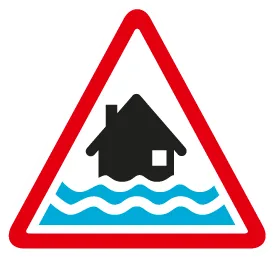
Low
9, Hertford, Gateshead, NE9 6DG is connected by rail. This terraced house in Gateshead is 0.15 miles from a petrol station and 0.49 miles from the post office.

Dunston train station (2.56 miles)
Heworth train station (2.60 miles)

Post office (0.49 miles)

Penny Petroleum Partnership (0.15 miles)
Distances are "as the crow flies" 🐦⬛
Do you work in insurance, finance or real estate? Tell your Head of Data that Chimnie can save businesses up to £2.5m a year with our upgraded real-time database covering every residential & commercial building in Britain.
 Learn more
Restaurants
Melts (0.24 miles)
Pubs / bars / clubs
The Stone Trough (0.31 miles)
Fast food
Cafes
Supermarket
Distances are "as the crow flies" 🐦⬛
Chimnie is the UK's only free property search engine. How helpful is the data we gave you for this address?
Use our property-specific risk report to uncover potential hidden risks: from radon levels and flood risks to planning constraints and environmental factors. Gain insights usually reserved for real estate agents and make well-informed decisions built on a foundation of thorough research.

Nursery
Chowdene Children's Centre (0.23 miles)
Primary
Good - OFSTED rating 2017
Secondary
University
Distances are "as the crow flies" 🐦⬛
Property karaoke 🎤🤘🎸
Use the dropdown to get a karaoke tour of this property, as if sung by your favourite band or musician!
Working in Insurance, Lending, or Property?
Chimnie helps you make better property decisions.
© 2026 Little Chimney Ltd. All rights reserved.
872 sqft
Terraced
Skip to section:
A terraced house in Gateshead. It is in the A council tax band. Its current energy rating is C.
House type
Terraced
Council tax band
~ A
Council tax cost
~ £1,633 per year
EPC rating
Broadband speed
~ 600 Mbps
Built surface
667 sqft
Roof type
Chimnie ipsum
Roof material
Chimnie ip
Construction material
Chimnie ipsum dolor
Window glazing
Chimnie ipsum dol
Heating type
Chimnie ipsum dolor sit
Solar panels
Chi
Extension count
Ch
Basement
Chim
CO2 emissions
Chimnie ipsum do
This is the current Bank of England 5-year fixed rate. Your own rate depends on your deposit, how much you borrow and how long for. Tap below to find your rate.
BoE rate
4.80%
Your rate
.
%
We analyse huge amounts of data to help you find the very best neighbourhoods in the UK, based on what matters most to you. This terraced house in Gateshead is located in a low pollution area with plenty of nearby natural spaces and good access to education.
This home's location is likely to be better than 50% of homes in Britain. This is calculated by combining the scores below.
This property is likely to have better nearby education than 91% of properties in Britain. See nearby schools
Average in Britain
Better
This property is likely to be safer than 23% of properties in Britain. There were 573 crimes within 500m in 2022.
Average in Britain
Better
This property is likely to have better nearby dining options than 52% of properties in Britain. It has 2 cafés, 6 restaurants, 19 fast food outlets and 5 pubs/bars within 1 mile. See local food and drink options
Average in Britain
Better
This property is likely to have better air quality than 53% of properties in Britain. It has recordings 7.35µg/m³ of PM2.5 air pollution particles. The UK has a legal limit of 20μg/m³. The World Health Organisation sets a limit of 5μg/m³. PM2.5 are pollution particles small enough to travel deeply into the lungs, and can cause a range of health disorders.
Average in Britain
Better
This property is likely to have safer roads than 45% of properties in Britain. There were 21 road traffic accidents within 1 mile in 2022.
Average in Britain
Better
This property is likely to be more peaceful than 31% of properties in Britain. It has a day-evening-night reading of 53 decibels.
Average in Britain
Better
This property is likely to have more natural spaces nearby than 52% of properties in Britain. Approximately 48% of the land within 1 mile is a natural space.
Average in Britain
Better
This property is likely to be closer to a supermarket than 68% of properties in Britain. The nearest supermarket to this property is 1.03 miles away. See closest supermarkets
Average in Britain
Better
This property is likely to have a lower flood risk than 44% of properties in Britain. This location has approximately 0.1% chance of flooding from rivers, coastal and surface water in any given year.
LOW SCORE
HIGH SCORE
This location has approximately 0.1% chance of flooding from rivers, coastal and surface water in any given year. Get a detailed report on how to reduce the risk.
Reduce the flood risk for this home
Low
9, Hertford, Gateshead, NE9 6DG is connected by rail. This terraced house in Gateshead is 0.15 miles from a petrol station and 0.49 miles from the post office.
Dunston train station (2.56 miles)
Heworth train station (2.60 miles)
Post office (0.49 miles)
Penny Petroleum Partnership (0.15 miles)
Distances are "as the crow flies" 🐦⬛
Do you work in insurance, finance or real estate? Tell your Head of Data that Chimnie can save businesses up to £2.5m a year with our upgraded real-time database covering every residential & commercial building in Britain.
Learn moreRestaurants
Melts (0.24 miles)
Pubs / bars / clubs
The Stone Trough (0.31 miles)
Fast food
Cafes
Supermarket
Distances are "as the crow flies" 🐦⬛
Chimnie is the UK's only free property search engine. How helpful is the data we gave you for this address?
Use our property-specific risk report to uncover potential hidden risks: from radon levels and flood risks to planning constraints and environmental factors. Gain insights usually reserved for real estate agents and make well-informed decisions built on a foundation of thorough research.
Nursery
Chowdene Children's Centre (0.23 miles)
Primary
Good - OFSTED rating 2017
Secondary
University
Distances are "as the crow flies" 🐦⬛
Property karaoke 🎤🤘🎸
Use the dropdown to get a karaoke tour of this property, as if sung by your favourite band or musician!
Working in Insurance, Lending, or Property?
Chimnie helps you make better property decisions.
© 2026 Little Chimney Ltd. All rights reserved.